|
Error processing SSI file |
||
|
Error processing SSI file |
||
| Error processing SSI file |
||
|
Error processing SSI file
|
The California Ocean Uses Atlas
Atlas Products and Tools 
Interactive Mapping Tool
This NEW application provides online access to the California Ocean Uses Atlas data through an interactive map environment. Use this tool to view, compare and contrast atlas data layers and analyses at the state and regional scales. Click here to launch the Interactive Mapping Tool. (First time users, please expect a one-time delay while the application loads. Application will not work on 64-bit browsers). 
GIS Data
The spatial database derived from the California Ocean Uses Atlas contains processed data for all the uses mapped with detailed metadata describing the process steps. A map document (.mxd) with sample layouts, layer files for applying suggested symbologies, and various accessory data layers used throughout the data compilation are also included in the zipped database. Click here to access the zipped geodatabase (ArcGIS 9.3) (30 MB). 
Maps
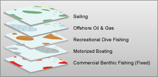
Various sorts of maps and analytical products can be derived from the California Atlas GIS data. Below are links to static map products for each use mapped at the state and regional scales. These maps can be used to inform ocean management decisions and identify hot spots and potential conflict zones for various combinations of ocean uses in California. Click here to access maps at the state and regional scale for all sectors and all uses. 
Documents
See links below for background documents and related resources for the California Ocean Uses Atlas: For Additional Information
Mimi D'Iorio, GIS Manager Disclaimer |
|

 The California Ocean Uses Atlas Project is an innovative public-private partnership between NOAA's Marine Protected Areas Center and