| Error processing SSI file |
||
| Error processing SSI file |
||
| Error processing SSI file |
||
Error processing SSI file |
About Marine Protected Areas
Lewis and Clark National Wildlife Refuge
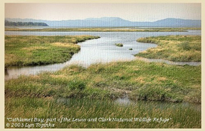
Lewis and Clark National Wildlife Refuge. The islands and estuary of the Lewis and Clark National Wildlife Refuge have always been a meeting place of waters and people. The Chinook and Cathlamet Indians were famed traders encountered by early European explorers and traders. As Meriwether Lewis, William Clark, and the Corps of Discovery journeyed toward their goal of the Pacific Ocean, they traveled through the estuary of the Columbia River in November 1805. Their notes and journals record our first scientific knowledge of the geography, plants, animals, and native peoples they encountered in the American Northwest. Lewis and Clark passed through the estuary and noted the weather, birds, and land. The refuge today looks much like it did when the Corps of Discovery traveled through. The earliest archaeological evidence of human habitation in the Columbia River Basin dates to 10,000 B.P. [Before Present Time] The earliest groups lived by fishing, hunting large mammals, and gathering plant foods. One particular root vegetable, the wapato, grows along shallow ponds, swamps, slow moving streams, and was harvested in abundance. For 200 river miles (322 km), from the ocean to above the city of The Dalles, Oregon, the Columbia River was home to peoples speaking several related Chinookan languages, beginning with the Chinook on the north bank and the Clatsop on the south side. The banks of the Columbia River were studded with villages of large rectangular longhouses constructed of huge cedar planks. The natural abundance of the region, including five types of salmon, wapato, camas, and other bulbs, berries, and many other plant and animal resources, sustained a complex culture, and made the lower Columbia one of the most heavily populated and richest areas north of Mexico. Did you know?
Learn more/get involved:
|
|
