Cultural Resources Inventory and Vulnerability Assessment at Bering Land Bridge National Preserve and Cape Krusenstern National Monument, Alaska
A Resource by the Marine Protected Areas Federal Advisory Committee (These statements do not necessarily reflect the positions of NOAA or the U.S. Government)
Adapted from Beavers, et al. in prep. Coastal Adaptation Strategies Handbook. National Park Service.
Goals
Climate change has increased the vulnerability of cultural resources in coastal locations at Bering Land Bridge National Preserve (BELA) and Cape Krusenstern National Monument (CAKR) along the northwestern Alaska coast. The Alaska Regional Office is developing and testing a GIS model to predict locations and vulnerability of these cultural resources.
Challenges and Needs
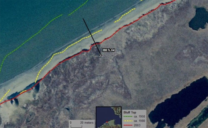
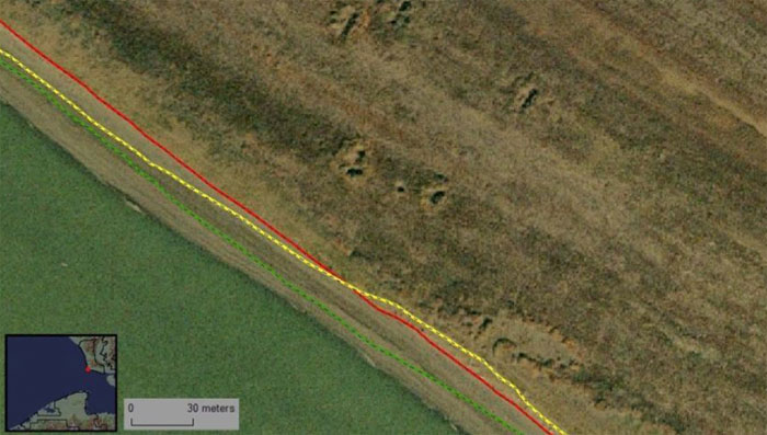
The 1600 km (1000 mi) of coastline along BELA and CAKR are experiencing increased storm impacts due to climate change effects including rising sea-level, melting permafrost, increasing storminess, and the failure of shore ice to form its usual protective barrier against wave erosion. The Alaskan Arctic has experienced average temperature rise at twice the rate of the rest of the world, and precipitation patterns are changing. Sea ice is not forming to its previous extent and thickness, and thick multi-year ice has mostly disappeared; satellite data indicate that the extent of the sea ice is decreasing by 3% per decade and submarine data show that the thickness has decreased by up to 1 meter. The ice plays a role in surface reflectivity, cloudiness, humidity, exchanges of heat and moisture at the ocean surface, and ocean currents. Summer ice is projected to disappear over most of the Arctic Ocean by 2020. Permafrost, which protects cultural resources by preserving organic materials, has warmed by up to 2°C (3.6°F) and is melting.
BELA and CAKR preserve some of the earliest most significant archaeological sites in North America including ancestral villages of the Inupiat people. Some of these prehistoric sites are being lost due to destabilization of the coasts and the resulting erosion that can be up to 3.6 m/yr (12 ft/yr). As the permafrost that encases the soil of the region melts, the stratigraphy, artifacts, and buried house remains that make up a typical site are exposed and then become victim to mechanical erosion from the waves and thermal degradation from the warmer temperatures that prevail on the bluff faces.
Already, exposed archeological sites litter the bluff faces that line the coastline of Bering Land Bridge National Preserve. Only a small percentage of the coastlines have been inventoried, and there is little information on the significance or condition of most of the vulnerable archeological sites. Therefore, some site locations are likely unknown and unprotected, and it is difficult to make informed decisions about management actions.
Responsive Actions
To build basic inventory knowledge and inform subsequent management actions, the Alaska Regional Office is creating a GIS-based vulnerability assessment to determine which areas of the coasts of CAKR and BELA are most vulnerable to erosion and which of those areas are most likely to contain archeological sites. The GIS-based model will combine predictive local climate scenarios produced by the SNAP program (Scenarios Network for Alaska and Arctic Planning), a coastal erosion model from the
Arctic Network (I&M program) and a model to predict the presence of archaeological sites based on physical site characteristics. The model will be tested first on its ability to predict the locations of known sites and then on its ability to identify the high or low probability of sites occurring in particular areas. This study will give us a more detailed overall picture of where erosion rates are greatest relative to the density of sensitive archeological zones, and will enable prioritization of future archaeological inventories.
Lack of relevant baseline data (e.g., site locations and conditions) has impeded this project. Consultation with communities affiliated with coastal areas of BELA and CAKR will help the parks incorporate traditional knowledge of climate impacts, record documented and undocumented archeological and ethnographic sites and features, and develop survey strategies and priorities. The project will also compile archaeological inventory data, Digital Elevation Models, Soil Maps, aerial imagery, and documentation including BIA ANCSA files, toponym studies and scholarly journal articles.
The initial phase of this project, identification of at-risk sites, will take 3–5 years to complete. Site treatment will be an ongoing process. This case study is an example of the following adaptation strategies:
- Conducting/gathering additional research, data, or products
- Conducting vulnerability assessments and studies
- Creating/enhancing technological resources
- Developing/implementing an adaptation plan