Texas Historical Commission's Research, Monitoring, and Evaluation Efforts
A Resource by the Marine Protected Areas Federal Advisory Committee (These statements do not necessarily reflect the positions of NOAA or the U.S. Government)
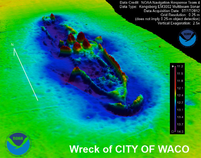
NOAA multi-beam image of City of Waco. (NOAA)
At the state level, the Texas Historical Commission (THC) maintains ArcGIS databases that have web connectivity for sharing information about the state's historic sites. A second restricted archaeological database provides information maintained by the THC and the Texas Archeological Research Laboratory that includes protected locations of archaeological sites, reported shipwrecks and submerged sites, and survey areas. This website includes archaeological site forms, report abstracts, and downloadable reports. The Archeological Sites Atlas incorporates data from the THC's Marine Archeology Program (MAP) and includes recorded submerged archaeological sites (more than 100), reported shipwrecks (more than 1800), and marine-based survey areas (more than 250). The MAP's internal ArcGIS database also contains information such as geo-referenced historic maps, locations of life-saving stations, lighthouses, ship channels, spoil placement areas, and pipelines – comprehensive data that helps the State Marine Archeologist better understand the historical and geophysical context and sites. This data was used to develop, in partnership with the Texas General Land Office (GLO), resource management codes that identify areas along the Texas coast that have a high probability to contain submerged cultural resources. This information is included on an online map-based database maintained by the GLO. The MAP utilizes volunteer marine stewards (Texas Archeological Stewardship Network) for dive reconnaissance and site monitoring and also has a student-internship program to assist in research and database management. The THC MAP has a small research vessel equipped for both survey and dive activities. Site investigation and monitoring is conducted by the THC and sometimes in collaboration with other state and federal partners. In one such example, the THC worked with NOAA's Office of National Marine Sanctuaries and Office of Coastal Study to collect data on City of Waco, a State Antiquities Landmark, off the Texas coast at Galveston. The survey concluded that the late 19th–century steamship, considered the state's highest fatality wrecking event, was in the same condition but more exposed on the seabed than in previous years. The wreck was originally surveyed and identified in 2003 and was the focus of THC dive investigations in 2004-2005; NOAA collected multi-beam and side-scan sonar data in 2012.